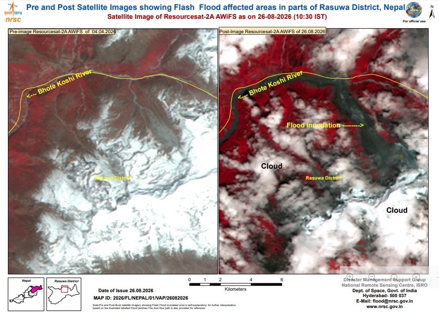
A devastating flash flood in Nepal’s Rasuwa region has drawn the attention of scientists across South Asia, with India’s National Remote Sensing Centre (NRSC), a key arm of the Indian Space Research Organisation (ISRO), carrying out a preliminary satellite based assessment of the disaster. Using a combination of Indian and international satellite imagery, NRSC scientists have mapped the scale of destruction and helped piece together the sequence of events that led to one of the worst mountain disasters in the region in recent years. India today has 56 satellites in orbit.
The satellite comparison revealed significant changes in the river corridor, with large stretches affected by debris deposition and flooding. The collapse generated a massive ice rock avalanche that thundered down a steep mountain valley. The resulting flash flood raced through the Trishuli river system, causing rapid inundation and widespread devastation. Reports from scientists studying satellite imagery have pointed to a cirque glacier collapse and a subsequent ice rock avalanche as a likely trigger for the disaster. To understand the scale and impact of the event, NRSC in Hyderabad undertook a rapid geospatial assessment. The imagery enabled scientists to map the altered landscape and understand how the disaster unfolded across the mountainous terrain. Such rapid satellite assessments play a critical role in disaster response by providing authorities with a clear picture of affected regions when ground access is difficult or impossible. The event has once again highlighted the importance of space technology in disaster management. From cyclones and landslides to floods and forest fires, satellite based monitoring has become an indispensable tool for emergency responders. In the case of the Rasuwa flood, the ability to compare images acquired before and after the disaster made it possible to quickly identify the impact zone and understand the mechanisms that drove the flood. Scientists studying satellite imagery believe the sequence likely involved an ice rock avalanche, temporary river blockage, formation of an impounded water body and the sudden release of accumulated water and debris. This combination transformed what might otherwise have been a localised mountain collapse into a destructive flood wave that travelled far downstream. While NRSC’s assessment focuses on mapping and understanding the event, experts familiar with the region suggest that the threat to India may be limited. However, ISRO itself has made no formal claim regarding the downstream impact on India. For now, the NRSC analysis stands as an important example of how Indian space assets are helping track natural disasters beyond India’s borders.
As a result, they believe the most severe impacts are likely to remain concentrated closer to the source region and within the affected Nepal and Tibet river corridors. The disaster appears to have begun high in the mountains of Tibet, where preliminary assessments indicate that a magnitude 4.9 earthquake may have triggered the collapse of a type of a glacier called a ‘cirque glacier’, according to NRSC’s assessment. Scientists compared pre disaster imagery from the European Sentinel 2 satellite acquired on August 24, with post disaster imagery from ISRO’s Resourcesat 2A captured on August 26. In addition, an earlier Resourcesat 2A image from April 4, 2026 was examined alongside the latest post flood imagery to assess terrain changes and identify damaged areas. Off the record assessments indicate that the origin of the disaster lies more than 200 kilometres from the Indian border. By combining data from Sentinel 2 and Resources at 2A, scientists have been able to reconstruct the probable chain of events and provide valuable insights into a rapidly evolving mountain disaster.
The avalanche is believed to have temporarily blocked a river channel before the barrier failed, unleashing a massive surge of water, mud, rocks and debris downstream.